Developing an ocean observation drone that can take off and land on water and navigate at sea
Prodrone Co., Ltd. (Headquarters: Nagoya City, Aichi Prefecture, President and CEO: Shunsuke Toya) and Penta-Ocean Construction Co., Ltd. (Headquarters: Bunkyo-ku, Tokyo, President and CEO: Takuzo Shimizu) have developed the ocean observation drone “Penta-Ocean Vanguard-DroneAqua” (hereinafter referred to as POV-DA), which can take off and land on water as well as navigate at sea. POV-DA is a drone that can take off and land on water and is equipped with high-precision GNSS, thrusters, and depth sounding sonar (Photo 1). The current position (X, Y, Z) and water depth of POV-DA that landed in the water can be seen in real time on the land-based operation screen. In addition, by specifying the horizontal position (X, Y) of the observation point on the operation screen, it is possible to use underwater thrusters to sail POV-DA to the observation point, or to maintain a fixed point at the observation point in the presence of waves and currents. Using these functions, it is now possible to easily and efficiently perform (1) water depth surveying and (2) wave observation by operating from land.
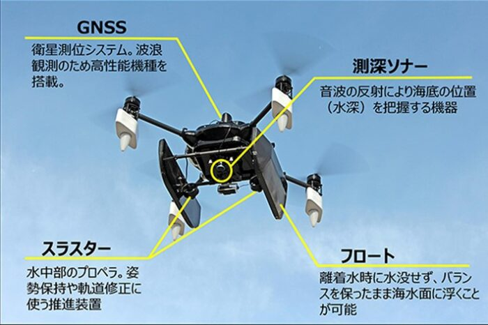
POV-DA panoramic view (Photo 1), document creation: Pentayo Construction
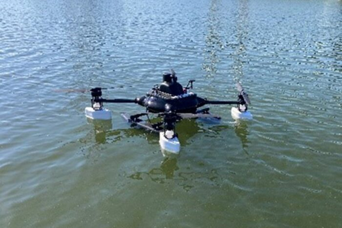
POV-DA Measurement status when landing on water
① Bathymetry function When managing the construction of breakwaters, quays, etc., it is not possible to directly visually confirm the underwater construction status, so bathymetric surveying*1 and red sounding*2 using survey vessels are commonly performed. The introduction of POV-DA has made it possible to shorten the time required for sounding, and since the sounding data is displayed wirelessly in real time on the operation screen, it is possible to grasp the progress of underwater work and the excess or deficiency of soil input, making it possible to quickly make decisions about continuing work. The depth sounding performance differs by about ±10cm compared to general bathymetric surveying methods, and we have confirmed that it has practical accuracy for construction management. ②Wave observation function In conducting construction and safety management for offshore construction, we judge whether or not construction is possible based on various weather and sea forecast data or wave observation data near the relevant point. In addition, before construction begins, we conduct visual inspections from the coast to determine whether or not construction is possible. With the introduction of POV-DA, the wave height and period calculated from GNSS data are displayed on the operation screen in real time, making it possible to understand the local wave situation and speeding up decisions on whether or not construction is possible. The difference between the POV-DA observation results and the wave height meter observation results is within 10% on average, confirming that they have practical accuracy for construction management. POV-DA not only contributes to more efficient construction management in offshore construction and faster determination of whether or not construction is possible, but also enables aerial photography from above, making it possible to quickly grasp the situation on both land and underwater in the event of a disaster. In the future, we plan to expand the functions of ocean measurement, such as installing a multi-item water quality meter and water sampler, and expand its use to preserve and survey the marine environment during offshore construction. *1 Bathymetry: A method of measuring depth while moving using single-element or complex-element acoustic sounding equipment. *2 Red bathymetry: A method of dropping a rope coated with red (lead) onto the ocean floor and measuring the water depth using the scale on the rope.■POV-DA specifications/performanceDistance between motor axes: 1280mm (860mm when folded) Overall height: 600mm Aircraft weight: 13kg (including battery and camera) Maximum flight time: 20 minutes Maximum speed: 60km/h Maximum flight wind speed: 10m/s Maximum sailing time when landing: 60 minutes Maximum sailing time when landing: Approx. 4 knots Maximum wave height for takeoff and landing: Approx. 2m Water resistance: IP55 equivalent Satellite positioning system: RTK-GNSS Sonar: BlueRobotics pingsonar
This article has been automatically translated into English using AI. The original content is written in Japanese. While we strive for accuracy, the translation may not fully capture the nuance of the original.
Related News
Establishment of Prodrone's First Mass Production Plant within Howa Machinery - Notice Regarding Third-Party Allotment of Shares with the Company as the Subscriber -