Developing a new drone that streamlines underwater and seabed observations - Toward achieving high real-time performance and mobility -

Aircraft used in this research (base: PD6B-TypeII, large platform aircraft with a maximum payload of 30 kg)
Prodrone Co., Ltd. (Headquarters: Nagoya City, Aichi Prefecture, President and CEO: Masakazu Kono) and Institute of Industrial Science, the University of Tokyo (Location: Meguro-ku, Tokyo, Director: Toshiharu Kishi) Lecturer Yusuke Yokota of the Undersea Observation Implementation Engineering Research Center have developed two new observation drones with the aim of increasing the efficiency and speed of underwater and seabed observations.
Understanding ocean fields and seafloor topography, and determining the location of the seafloor are essential in many academic and industrial fields such as oceanography, seismology, fisheries, and resource exploration.However, the means to observe the ocean and seafloor are often based on ships and buoys as platforms, and a lack of real-time performance and mobility are common issues. On the other hand, the use of drones, which have low aircraft and fuel costs and very low human and time costs, is rapidly progressing on land, but there is currently an overwhelming lack of actual examples of their use as ocean observation platforms, as well as data on the operation and measurement of drones.
In this research, we experimentally developed an underwater/bottom observation device that achieves high real-time performance and maneuverability by utilizing a drone that can automatically reciprocate near the sea surface while controlling its position with high precision at speeds of 40 km/h or more, and conducted experiments off the coast of Yaizu City, Shizuoka Prefecture. The first drone is equipped with functions for automatically dropping marine observation equipment and recording data by applying the fixed point holding and automatic navigation functions cultivated in land operations. Although there were periods of stormy weather with winds exceeding 5 m/s and heavy rain, we confirmed that we could repeatedly observe the same spot every 15 minutes as scheduled. This observation technology can be used to speed up and simplify ocean understanding, simultaneously understand multiple points, understand km-scale ocean structure, and improve the accuracy of ocean acoustic engineering. The second drone has the unique ability to land on the sea surface, making it capable of precise satellite positioning using high-precision GNSS (Note 1) on the sea surface. We confirmed that the system can hold sea level and record sufficient position and motion data, which is required for observation under bad weather conditions, opening up the possibility of application to submarine topography surveys, crustal deformation surveys, etc. It was also demonstrated that mobile buoy observation is possible, and can be used to realize near-real-time measurements of the marine environment.
Through further research and development, we aim to realize ocean observation drones that can be used in a wider range of applications.
■The newly developed drone
(1) Drone that drops underwater observation equipment
Drone (base: PD6B-TYPEⅡ ) was developed. It can automatically travel back and forth to the observation point at over 40 km/h, and the XCTD (Note 2) automatic drop mechanism is designed to allow observers on land to press the observation switch from a tablet or remote control whenever they wish.
In the experiment, an XBT (Note 3) observation test was also conducted at the same time, and it was confirmed that all observation data could be obtained satisfactorily. One observation was carried out approximately every 15 minutes. Although the weather conditions on the day were stormy at times with winds exceeding 5 m/s and heavy rain (the video was shot during good weather), repeated observations of the same spot were carried out as planned. This observation technology not only makes it possible to speed up and simplify oceanographic observation in ports, fish farms, etc., but also enables simultaneous observation of multiple oceanographic points even in distant ocean areas by using it from ships at sea. It can also be used to understand ocean structure on a km scale and improve the accuracy of ocean acoustic engineering.
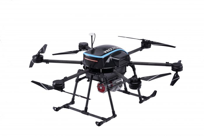
Aircraft used in this research (Base: PD6B-Type II, photo shows example with surveying equipment installed)
(2) Sea-landing drone equipped with high-precision GNSS
Sea surface landing type drone (base: PD4-AW-AQ ) was developed. Since they are exposed to high waves and winds on the actual sea surface, it is necessary to control landing and takeoff to a high level. In addition, in order to conduct ocean floor observations under such adverse environments, it is necessary to obtain precise position data and aircraft motion data. This drone can hold the sea surface as a drifting observation buoy while determining its position with high precision, and can move flexibly by taking off and landing on water. Similar to (1), it is also possible to automatically instruct navigation and movement.
In the experiment, we performed observation tests under bad weather and verified high-precision GNSS data and aircraft vibration data, and confirmed that we were able to obtain the sea level holding performance and data required for sea surface, underwater, and seabed observations (some data is shown in Figure 5). This experiment demonstrated that it is possible to accurately determine the position of a platform that can withstand the installation of precision acoustic equipment, opening up the possibility of application to submarine topography surveys, crustal deformation surveys, etc. It has also been demonstrated that mobile buoy observation is possible, and can be used to realize near-real-time measurements of the marine environment, such as coastal waves, coastal seawater sampling, and easy understanding of marine plastic debris. In particular, its ability as a buoy is extremely useful in that it allows for extremely easy loading and unloading. However, for use in the distant sea, there are still issues with the short flight time and wave resistance, and further research and development is required in this regard.
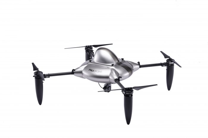
Aircraft used in this research (base: PD4-AW-AQ, tap flight water landing drone)
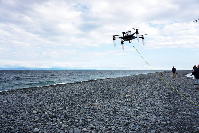
During this experiment
(Note 1) GNSS: Positioning observation system using satellites such as "GPS" and "Michibiki"
(Note 2) XCTD: Undersea electrical conductivity, water temperature, water pressure measuring device
(Note 3) XBT: Undersea water temperature measuring device
For details of the experiment, please see the materials published by the University of Tokyo. https://www.iis.u-tokyo.ac.jp/ja/news/3296/
■Experiment video
Contact information
(Regarding this research)
The University of Tokyo, Institute of Industrial Science, Undersea Observation Implementation Engineering Research Center
Lecturer: Yusuke Yokota
E-mail: yyokota@iis.u-tokyo.ac.jp
(Regarding drones)
Prodrone Co., Ltd. Sales Department
Shiyu Kojima
E-mail: info-jp@prodrone.com
This article has been automatically translated into English using AI. The original content is written in Japanese. While we strive for accuracy, the translation may not fully capture the nuance of the original.
Related News

Establishment of Prodrone's First Mass Production Plant within Howa Machinery - Notice Regarding Third-Party Allotment of Shares with the Company as the Subscriber -