World's first successful fully autonomous flight using KDDI and "smart drone" mobile communication network and 3D map
Prodrone Co., Ltd. (Headquarters: Naka-ku, Nagoya City, Aichi Prefecture, President and CEO: Masakazu Kono, hereinafter PRODRONE) is a 4G company with the cooperation of KDDI Corporation (Headquarters: Chiyoda-ku, Tokyo, President and Representative Director: Takashi Tanaka, hereinafter KDDI) and Nagaoka City, Niigata Prefecture. We conducted a fully autonomous flight experiment of a "smart drone" using an LTE mobile communication network (Note 1), a "3D map" and a "drone port." In this experiment, the drone successfully completed a long-distance flight for the first time in the world (Note 2), covering a total distance of approximately 6.3km from the takeoff point, via an automatically recharging "drone port", and returning to the landing site after spraying chemicals at a terrace pond where Nishikigoi are cultivated.
PRODRONE and KDDI aim to build an infrastructure that will enable safe, long-distance autonomous flight by smart drones using mobile communication networks. This demonstration experiment involved setting a safe flight altitude using a ``3D map'' and automatic charging using a ``drone port,'' which are necessary for this purpose, and confirmed that long-distance autonomous flight of a drone is technically possible by utilizing these technologies.
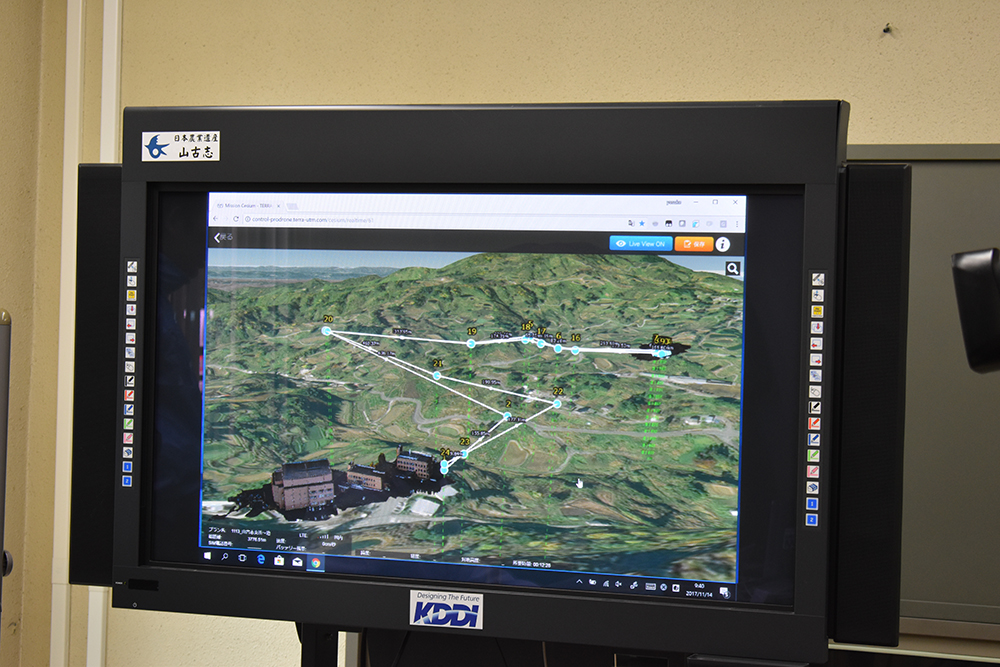
three dimensional map
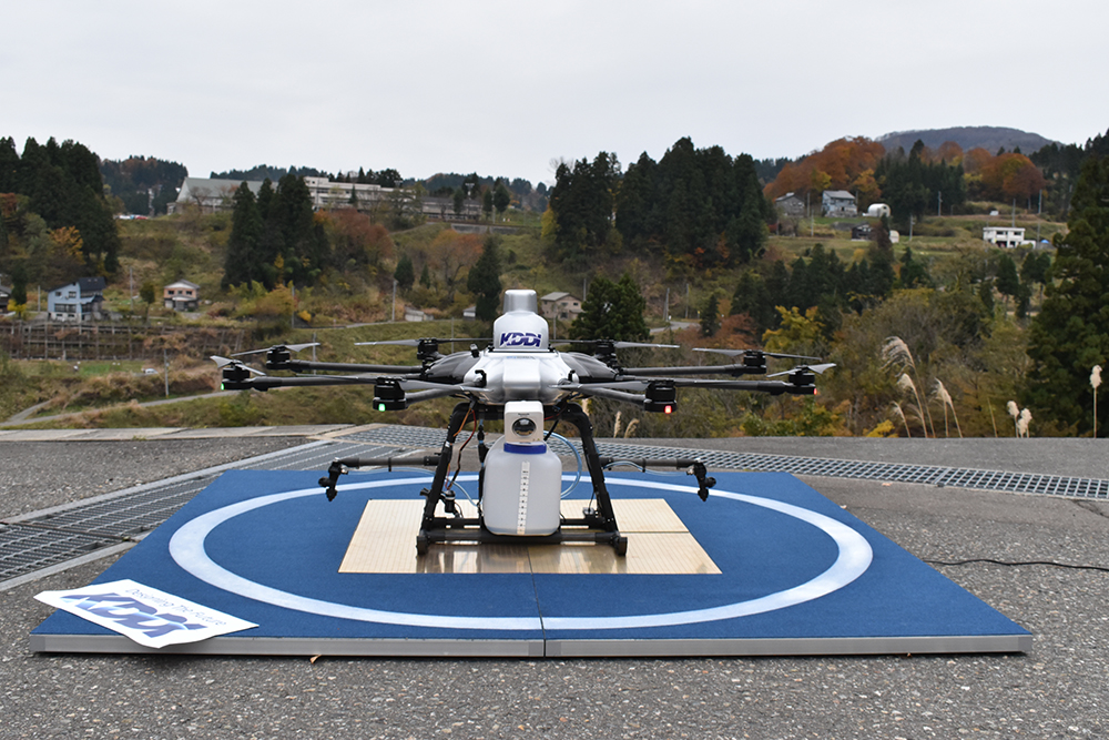
drone port
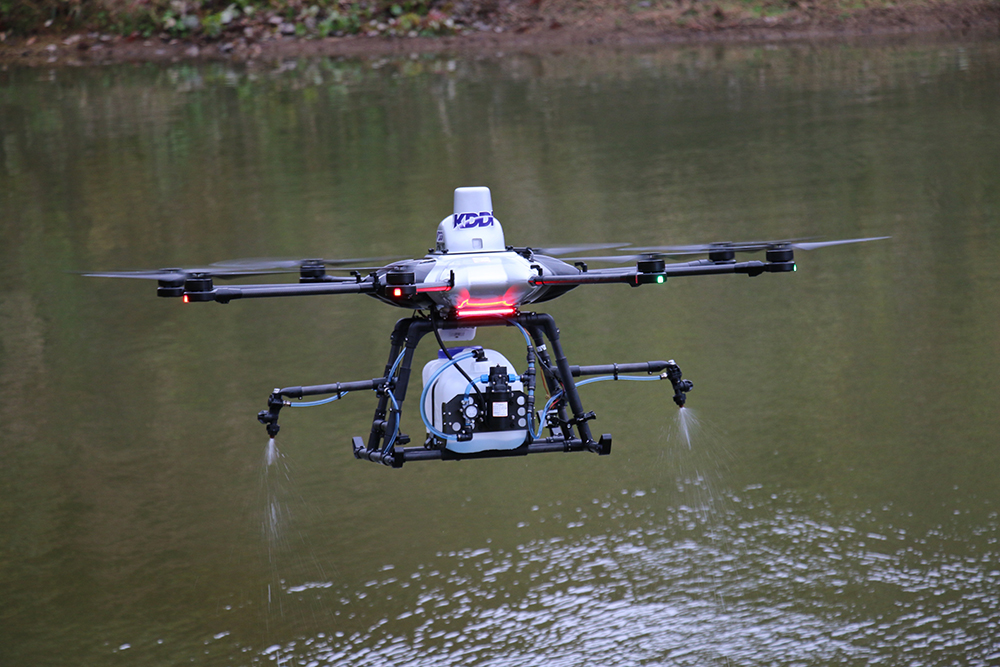
Spraying chemicals on terrace ponds
■Background of the demonstration experiment
Yamakoshi, Nagaoka City, Niigata Prefecture, where this demonstration experiment was conducted, is the birthplace of Nishikigoi and one of Japan's leading Nishikigoi carp farms. Frequent feeding, spraying of chemicals to remove parasites, management and maintenance of cages, etc. take time and effort. In particular, spraying pesticides to remove parasites, which is essential for raising beautiful and large Nishikigoi, is time-consuming and labor-intensive as the spraying must be carried out evenly across the terraced ponds by boat.
■Proof experiment content
1) Setting a safe flight altitude for the “3D map”
The three-dimensional map used in this demonstration experiment was jointly developed with Zenrin Co., Ltd. (Headquarters: Kitakyushu City, Fukuoka Prefecture, President and CEO: Zenji Takayama, hereinafter referred to as Zenrin) and Terra Drone Co., Ltd. (Headquarters: Shibuya-ku, Tokyo, President and CEO: Toru Tokushige, hereinafter referred to as Terra Drone), with whom Zenrin Co., Ltd. (Headquarters: Kitakyushu City, Fukuoka Prefecture, President and CEO: Zenji Takayama, hereinafter referred to as Zenrin) has a business alliance for the development of a "smart drone platform" that realizes safe drone flight using mobile communication networks. By using a ``3D map'' for autonomous flight of the drone, a safe flight altitude is automatically set. It is possible to detect height differences in terrain such as mountains and hills, as well as obstacles such as buildings, and in this experiment, we succeeded in automatically identifying height differences of 100 meters or more.
2) Automatic charging of “drone port”
In addition, the "Drone Port" uses an automatic landing function developed by PRODRONE that uses image recognition to accurately land at the desired location and automatically start charging. The aircraft automatically takes off when it senses that charging is complete, enabling long-distance automatic flight via the drone port.
Demonstration experiment
■今後のビジネス展開
今回の実験では、散布場所を設定するだけで高度を自動設定し、効率的な農薬散布が出来ることがわかりました。今後、この技術を用い、モバイル通信ネットワークを活用したスマートドローンの長距離自律飛行インフラが整理されれば、農地監視や農薬散布などの農業分野だけではなく、地形や設備の測量、施設の警備、災害状況の把握、遠隔地への配送など、さまざまな分野での活用が期待されます。
For more information on the “4G LTE Traffic Management System” and KDDI’s smart drone initiatives, please visit the Smart Drone website. (http://smartdrone.kddi.com) Please refer to
Note 1) The 2.4GHz band (ISM band) is normally used for drone control and data transmission, but when an LTE communication module is installed on a drone, it will be used as a wireless station (practical test station) established by KDDI on a trial basis for the purpose of putting it into practical use, to the extent that it does not interfere with the operation of existing wireless stations, etc. In addition, drone flights are conducted based on the test plan of the Practical Testing Bureau.
Note 2) According to Terra Drone research. It is the first fully autonomous flight that utilizes mobile communications networks and 3D maps, including automatic takeoff and landing from a charging port.
■Contact information regarding this matter
Prodrone Co., Ltd.
in charge
:Sales Department Matsunaga
:press@prodrone.com
location
: 16th floor, Sakatane Sakae Building, 2-4 Shinei-cho, Naka-ku, Nagoya, Aichi 460-0004
This article has been automatically translated into English using AI. The original content is written in Japanese. While we strive for accuracy, the translation may not fully capture the nuance of the original.
Related News

Establishment of Prodrone's First Mass Production Plant within Howa Machinery - Notice Regarding Third-Party Allotment of Shares with the Company as the Subscriber -